
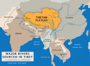
Major rivers sources in Tibet. Buckley, M. (2014) Meltdown in Tibet.
Tibet represents the largest body of ice and permafrost outside the Arctic and Antarctic regions. Melt water from Tibet’s glaciers and snowfall, and the rivers arising in Tibet provide 40% of the Earth’s population with fresh water.
China commenced large scale dam building in 1958 and now holds half the world’s dams inside its borders. Two་thirds of these 87,000dams are located on the Tibetan Plateau་with many new megadam hydropower plants underway – hydropower is the centrepiece of China’s expanding renewable energy strategy.
The human cost of the dams is the displacement of an estimated 23 million people while dam breaks have killed approximately 300,000 people.The ecological cost of the dams has been documented, as diversions and alterations in natural hydrological flows put river ecosystems under pressure, often beyond the point at which they can adapt.
The exploitation of rivers on the Tibetan Plateau is escalating. Shuang Jiang Kou dam is currently being constructed along the GyelmoNgul Chu (the Dadu River – a Yangtse tributary) within Sichuan Province. This 312m high embankment dam, with a 3.1bn m³ reservoir, is expected to be the tallest dam in the world when completed this year (2018). Its wall will be higher than the Potala Palace (from valley floor to rooftop) and its reservoir will hold over one-fifth the capacity of Tibet’s holy Yamdrok་Yumtso Lake.
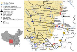
Dams constructed or planned along the Yangtse and its three main tributaries. Buckley, M.(2014). Meltdown in Tibet.
A13-dam cascade is planned for the Nu River which originates on the Tibetan Plateau and flows through Myanmar where it is known as the Salween. It is the last free-flowing river in Asia. Developments for the largest cascade of hydroelectric dams in the worldwhich are planned for it are currently on hold due to China’s present economic lag and power oversupply. However, if they go ahead, the dams will likely displace 50,000 people – people who are predominately of ethnic minorities, including Tibetans.
The Yarlung་Tsangpo river, with its source at Mount Kailash, has a proposed 27 more dams. In addition to the Zangmu power station built close to Gyaca in the Tibetan Autonomous Region (TAR), there are plans for a potential northward rerouting of water at the Great Bend, which flows by Pei, Tibet: another major scheme.
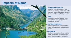
Impacts of Dams summary. Sourced from www.researchgate.net.
These immense damming operations are already impacting downstream nations through altered and reduced river flows. Spearheaded by the Central Tibetan Administration, there is a campaign to make China accountable under the United Nations water convention, as well as promoting global awareness of the issues. His Holiness the Dalai Lama has said, “The Tibetan plateau needs to be protected, not just for Tibetans, but for the environmental health and sustainability of the entire world.”
Please see tibetnature.net for the full article.
 Print
Print Email
Email